

Making a record at the Public Utilities Commission
Update: January 28th: According to informed sources, the ALJ did not reverse himself and allow the subpoenas to issue. However, the DNR has apparently asked to testify, but the MPCA has not. It would be very interesting to know the communications that took place between the DNR and the MPCA, on the one hand, and the Department of Commerce and the Public Utilities Commission, on the other, after the after the PCA’s Patrice Johnson sent the report to the Department of Commerce that is linked below. I still think this is fishy.
[Be sure to read the second update below; it is the most important part of the story.]
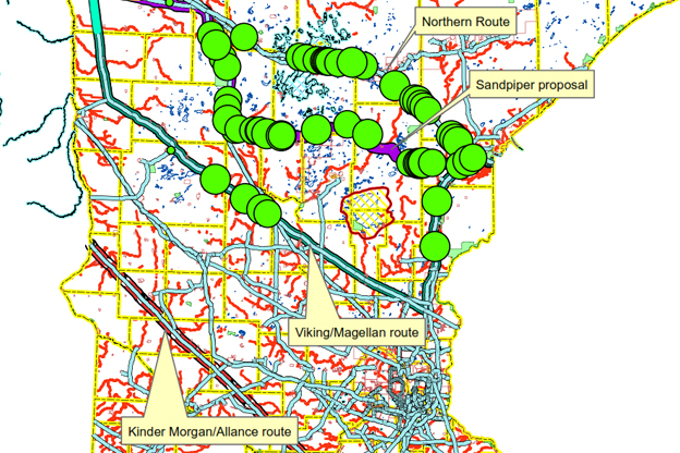
There is a hearing set to start on the application for the Sandpiper pipeline project, set to start on January 27th at the Minnesota Public Utilities Commission. The pipeline applicant, North Dakota Pipeline Company LLC, proposes the “Sandpiper” route shown in the graphic. The map is part of a submission to the Department of Commerce (parent agency of the Public Utilities Commission) by the MPCA in May of 2014, discussing the four routes shown.
The pipeline, if constructed, will bring Canadian tar sand oil — which we know is pretty volatile — across Minnesota. It’s kind of a mini-Keystone XL project. In the submission (on page 6) the author makes the following observation:
Any water body crossing, especially streams, rivers, or flowages of any kind that can carry oil downstream, poses the risk of creating large scale environmental damage in the event of a release. If possible, it is best to avoid crossing surface waters altogether with oil pipelines in order to minimize this risk. However, if a water body, bog or otherwise sensitive area is to be crossed, then serious consideration should be given to whether the site can be accessed quickly in the event of a release to contain the product, minimize migration of the product into surface waters, soils and groundwater, and perform cleanup operations. In situations where roads have to be constructed to access a spill, the act of constructing the road, excavating and clearing vegetation can all exacerbate the damage that the spill itself created.
The green dots on the map show the locations of concern according to the criteria described above. The “Northern” route and the “Sandpiper” route obviously cross a surface water-rich part of the state.
For the upcoming hearing, one of the intervenors in the application proceeding, the Minnesota Center for Environmental Advocacy (representing the environmental group Friends of the Headwaters), requested that personnel at the MPCA and the Department of Natural Resources, who assisted in the preparation of the linked submission, be subpoenaed to testify about matters in the report.
The Administrative Law Judge assigned by the Office of Administrative Hearings to the case, said “No.”
What do you mean, “No,” Judge? [My question, not the MCEA’s] Here’s the order. At least he gave the MCEA the opportunity to reapply, which it has done; as far as I know, there is no ruling on the reapplication yet.
And the funny thing is, nobody objected to or moved to quash the subpoenas, including the PCA or the DNR. The personnel at the agencies that the MCEA seeks to subpoena obviously have opinions on this matter, already formed and contained in the linked submission, that they could elaborate on — without having to do additional work. They’ve already done a lot of field work — almost certainly more than anybody else — that would add immeasurably to the record.
It its reapplication for the issuance of the subpoenas, the MCEA observed that the failure to issue them is reversible error, and I am certainly inclined to agree.
Update: Okay, that’s harsh. But there are probably no persons extant who know more about the environmental risks inherent in the Sandpiper project.
And it’s worth remembering that that a pipeline just ruptured in the Yellowstone River in Montana:
The Poplar pipeline, a system near Glendive, Montana, sprung a leak Saturday, releasing crude oil into the Yellowstone River. Oil was spotted as far as 60 miles downriver from Glendive.
Further update: Inexplicably, the Pollution Control Agency and the Department of Natural Resources did not intervene in the case to put their oars in the water on the permit and siting issues. The subpoenas may be the only way to get benefit of the views of the employees of these agencies.
Thanks for your feedback. If we like what you have to say, it may appear in a future post of reader reactions.